Find
Measure distance and area
Use the Measure tools to measure distances and areas.
To locate a Latitude and Longitude coordinate
The Latitude/Longitude tool allows you to enter
Latitude and Longitude coordinates and locate them on the map.
To open the Measure tools
- In the Tools tab of the Console, click the Measure title bar to open/close the tool.
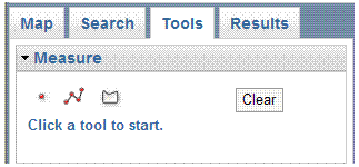
- There are three available options.
See the instructions below for measuring a line or a polygon (area) or to find the x,y coordinates of a location on the Map.
- The results of any Measure task will be displayed until you complete another Measure task or close the Measure box.
To find X,Y coordinates
- Click the Point button
 to activate the tool.
- Click a location on the map. The location is identifed with a circle and the coordinates
are displayed in the Measure box.
- The coordinates are provided in Virginia State Plane (X, Y Coordinates) and Decimal Degrees (Latitude & Longitude).
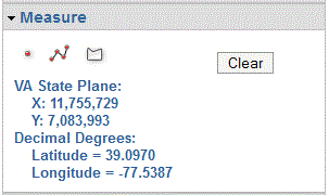
- To erase the point from the map, click the Clear
button inside of the Measure dialog box or the
 Clear Map button.
Additionally, the X,Y coordinates of the mouse cursor's current position are always displayed in the bottom right corner of the Map Screen.
To measure a line
- Click the Line button
 to activate the tool.
- Click the map for the start point of the line you want to
measure. As you move the mouse from this location, you will see a dashed line stretching
to the current position.
- Move the cursor to the second point of the line. If you only
want to measure one straight-line segment, double-click at
this location. Otherwise click once with the left mouse button.
- At the last vertex, double-click to end the line.
- The Total Length of the line, for all segments together, is displayed.
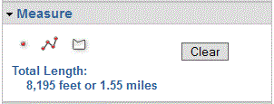
- To draw a new line, simply click on the map to start
the new line. The existing line will not be erased or the Total Length changed until the new line is complete.
- To erase the line from the map, click the Clear
button inside the Measure dialog box or the Clear Map button.
To measure an area
- Click the Polygon button
 to activate the tool.
- Click the map for the start point of the polygon you want to
measure. As you move the
mouse from this location, you will see the line stretching
to the current position.
- Continue clicking the map to add the points (vertices) of the polygon. New
vertices add line segments connecting to the previous vertex.
- At the last vertex in the polygon, double-click the mouse.
You do not need to click at the start point again.
- The Area and Perimeter of the polygon are displayed.
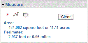
- To draw a new polygon, simply click on the map to start
the new polygon. The existing polygon will not be erased or the Area and Perimeter changed
until the new polygon is complete.
- To erase the polygon from the map, click the Clear
button inside the Measure dialog box or the Clear Map button.