Find
Identify features on the map
You can get more information about features on the map by using the
 Identify tool on the Main Toolbar.
To identify a feature
- In the Toolbar, click the
Identify button.
- You are presented with a drop down list of the Data Groups from the
Contents section of the Console.
- Click or hover the mouse over the name of a Data Group to open the list of identifiable layers within that group.
- Click on the data layer of interest and then click the feature on the map that you want to Identify.
- Some polygon features, such as parcels, will automatically be highlighted on the Map.
For all polygon features, you have the ability to highlight and zoom to the feature by clicking (show) from within the Identify info window. Click the feature again to display the info window.
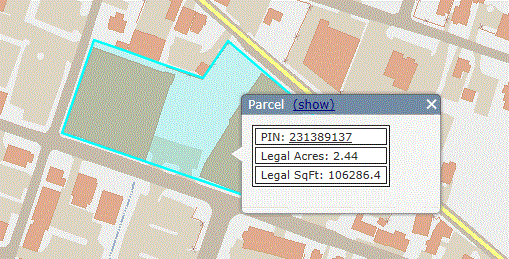
- For results containing PIN, view assessment information by clicking on the PIN number in the results.
The Loudoun County Real Estate Tax, Assessment & Parcel Database will open in a new window.
- For point or line features more than one feature may be returned with one map click. Click (show) to highlight a feature on the Map.
Click (zoom) to zoom in to a feature on the map.
- To close the Identify info window click the close button
 in the upper right corner of the box or click the
 Clear Map button in the main Toolbar.