Find
Aerial Archive
Use the Aerial Archive tool to view aerial imagery from previous years.
To open the Aerial Archive tool
- In the Tools tab of the Console, click the title bar Aerial Imagery.
- The Aerial Imagery box expands to show the tool.
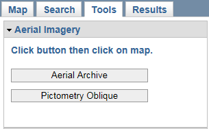
- Click the Aerial Archive button to activate the tool and then click on your location of interest on the map.
- The Aerial Archive application opens in a new browser window and zooms to the clicked map location.
- Additional help is available by clicking the
 Help button in the Aerial Archive application.
For Pictometry Oblique instructions, see the tool help page.